
How I Learned To Fly
I learned to fly while I was working at Xerox ETC (Eastern Technology Center) in Rockville Maryland. I really liked working at ETC. I had a great boss, interesting projects, wonderful co-workers. One of them, Frank Schmidt, was a CFI (Certified Flight Instructor) as well a the manager of the drafting department.
Frank Schmidt believed that everyone should get their pilots license. He taught ground school, for free, during lunch break. He also had an arrangement with the FBO (Fixed Base Operators) at a tiny local airport (Davis) to rent Piper Cubs for $5 an hour. That, plus the $5 an hour he charged for instruction time, made learning to fly quite affordable.
Davis Airport
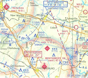
I learned to fly at Davis Airport. Davis Airport (FAA LID: W50) is a privately owned, public use airport located three nautical miles (6 km) north of the central business district of Laytonsville, in Montgomery County, Maryland, United States. When I learned to fly there the airport was owned by Mr. Paily who was also the A&P (Airframe and Powerplant) mechanic for the field. Mr. Paily had been a fighter pilot (P-47 Thunderbolt) in World War 2 and had been injured in a crash. He needed crushes to walk but still managed to maintain all of the airplanes on the field.
Although the sectional claimed that the runway at Davis is 2200 feet long (current sectional claims 2000 feet), the useable portion of the runway was really only 1800 feet. There was a hump in the runway and the west 300 feet of the runway was downhill. As a result, when landing from the east, the direction of the prevailing winds, you needed to land and come mostly to a stop in 1800 feet or you were at risk of not stopping before the fense at the west end of the field. To make matters even more interesting, along the east end ot the field were high tension power lines.
Learning to fly at Davis taught me how to do short field landings and steep approaches. That knowledge has proved valuable many times while flying around the country.
First Real Cross Country
114 CFR 61.1(b)(3) defines a cross country flight as one that that includes a point of landing that is at least a straight-line distance of more than 50 nm from the original point of departure. Most private pilots accept this definition and consider flights of 50 miles or more to be a real cross-country. I have a different definition of a real cross-country
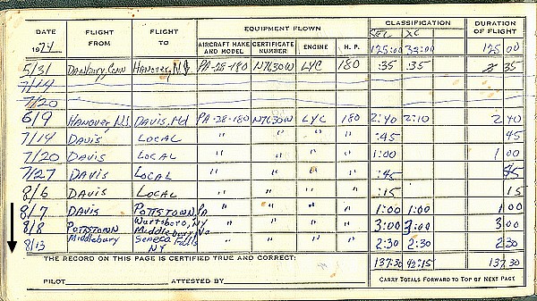
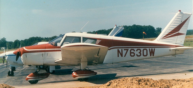
In August of 1974, I packed up my traveling gear and my wife to be, and set off on a journey that would redefine my concept of a cross-country. The first part of the trip took us from Gaithersburg MD to Middlebury, VT where Carol's (my first wife) family had a summer home/farm. We were married there and then the real adventure began.
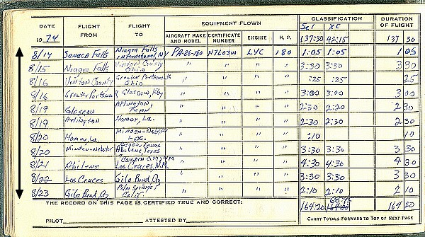
With less then 200 hour experience flying, no IFR (Instrument Flight Rules) training, no experience flying into a controlled airport or controlled air space, and a plane that had flakily radios, only one reliable VOR (GPS had not even been invented), we set out to fly across the USA.
The next destination on our journey was Niagara Falls (we were young and naive and though that Niagara Falls was the ideal honeymoon destination). The falls were magnificant, we rode the "Maid of the Mists" and even crossed the border and visited Canada. We then pushing on to Glasgow, KT to see Mammoth Cave. From there we continued to head south so we could cross the Rockies to the south where they are lower (we did not have oxygen in the plane).
We were in the Rockies as we flew from Abilene Tx. to Las Cruces, NM, and from Los Cruces, NM to Gila Bend, AZ. Flying the Rockies is a challenge is a small plane and in the summer you need to be safely back on the ground by mid-afternoon when the thunderstorms fill the passes. Once through the Rockies it was easy flying the rest of the way to the coast. We had a lot of adventures along the way, but I will save those for another stories.
Flying the Wedge
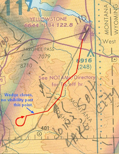
My girlfriend (now my wife), Amy, and I were on one of our month long August flying vacations when we encountered the wedge. We had spent some time in Yellowstone National Park and it was now time move on. The weather at Yellowstone was overcast but Flight Service told me that once we passed through the pass to the south, the weather was clear. Based on that data we took off bound for Oregon.
What Flight Service told me was totally incorrect. We started to see ground fog building and the cloud ceiling lowering while we were still in the pass. I would have turned around there and then but the pass was too narrow to safely execute a 360° turn.
Just after we cleared the mouth of the pass, the wedge closed down on us. Everything was featureless white. I went on instruments (I had some IFR training at this point) and asked Amy to watch for terrain. Then, using only the compass and my watch, I executed a teardrop maneuver like I had read about in a book on flying.
God was with us and I am a good mathematician. I executed the teardrop perfectly and when we broke out of the clouds the pass was right in front of us.
After we landed I called Flight Service and told them about the real conditions on the far side of the pass. He thanked us for our PIREP (Pilot Report) and told us that they did not have any reporting stations in the valley where we encountered the wedge. I asked why they had told us that the weather was clear in the valley beyond the pass and the man said that it was the weather service prediction for the area. I asked why they had not told us that it was just a prediction and the said that it was Flight Service's policy not to include that type of data in a weather briefing unless specifically requested.
I learned valuable lessions that day about Flight Service; the questions to ask and that they are not to be trusted. Knowing those two things helped Amy and I stay alive on other flying adventures.
Flying the Bermuda Triangle
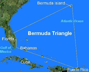
Back when I had my own consulting company (Future Concepts, Inc.) and my own plane (Piper Cherokee 180), I made a habit of taking all of August off and doing something interesting. One year my girlfriend (now my wife) and I decided to fly the Caribbean.
We had a lot of adventures on the trip, but the most interesting was the flight between Florida and the Bahamas. That part of the trip took us through a corner of the Bermuda Triangle and gave us an insight into why the Triangle has claimed so many people and vessels.
We knew from reading the charts and reports that magnetic compasses were not to be trusted in that area, but it is a very different thing to experience that phenomena first hand. Even more alarming was how fast weather changed in that area. We saw clear areas of sky change to thunderstorms capable of knocking planes out of the sky and sinking ships in a matter of minutes.
We did not see any sign of alien activity or holes in the space-time continum while flying in the triangle, but we did see plenty of evidence of conditions that could cause planes and ships traveling at night (when most of the disappearances occur) to vanish. This might not explain all of the Triangle mysteries, but I think it explains a lot of them.